Realist: New Premium Flood Maps are now available for purchase effective July 14th, 2022
Available to agents for the first time through Realist®, Premium Flood Maps go beyond FEMA flood determination data to provide a comprehensive analysis of a property’s true flood risk. With Premium Flood Maps, agents can give their clients flood risk information they won’t find anywhere else, emphasizing the agent’s value as an expert and trusted advisor.
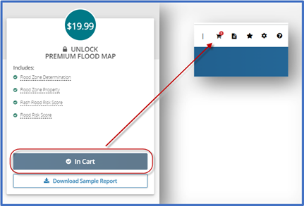
Add Premium Flood Map report to cart
To begin using Premium Flood Maps report, search for the subject property. From the Property Details report, you can click the “Flood Maps” tab to access the Flood Maps report.
If you previously had access to the Flood Maps report tab, you’ll notice that your new flood report has updated content and design. See an an example of the new Standard Flood map below:
Note: there are two distinctive Flood Map Reports available:
- Standard Flood Map Report
- Premium Flood Map Report
#
Standard Flood Maps
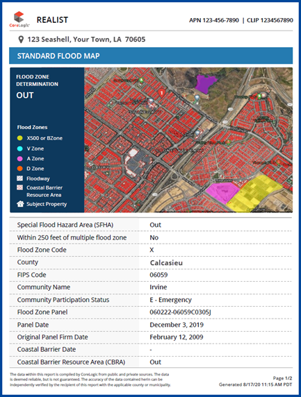
The Standard Flood Map report has a new user interface. This report shows a property map with FEMA flood zone determination, showing whether a property is “In” or “Out” of a federally designated-flood zone.
The Standard Flood Map report includes the following report attributes and definitions:
| Term | Definition |
| Special Flood Hazard Area (SFHA) | Indicates whether the property location is “In” or “Out” of a Special Flood Hazard Area (100-Year floodplain). |
| County | The county where the property is located. |
| Community Participation Status | The National Flood Insurance Program (NFIP) status of the community in the declared counties. |
| Original Panel Firm Date | Effective date of the map. |
| Within 250 feet of multiple flood zone | Provides a “Yes” or “No” response to whether the property is within 250 feet of the SFHA boundary. |
| FIPS Code | The five-digital state and county FIPS code. |
| Flood Zone Panel | 2-4 digit number and suffix assigned by FEMA for the map panel. |
| Coastal Barrier Date | Returns date of CBRA classification, if available. |
| Flood Zone Code | Flood zone for the property location based on FEMA. |
| Community Name | Name of the community. |
| Panel Date | Date of the FEMA map panel. |
| Coastal Barrier Resource Area (CBRA) | Coastal Barrier Resource Act (CBRA) protects areas that serve as barriers against wind and tidal forces caused by coastal storms and serves as habitat for aquatic species. Returns “In” or “Out” to identify whether the property is within a CBRA zone. |
You can still download the Standard Flood Map report to print or email.
Premium Flood Map Report
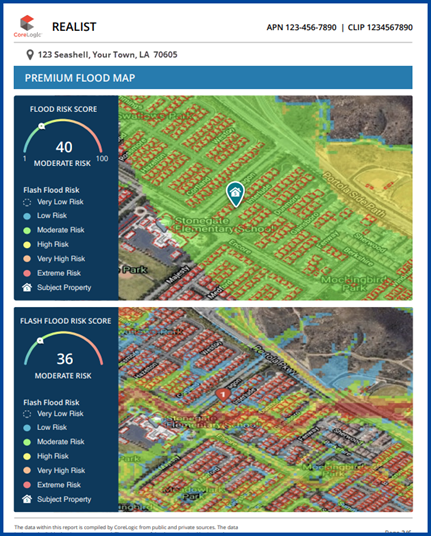
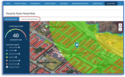
The Premium Flood Map Report is an upgradable flood map report available for certain properties that provides flood risk assessment data with two scoring models from CoreLogic:
- CoreLogic Flood Risk Score
- CoreLogic Flash Flood Risk Score
In addition to these two scores, the Premium Flood Map Report includes the following report attributes and definitions:
| Term | Definition |
| Distance to 100 yr Flood Plain | Distance in feet between the property and the boundary of the 100-year flood zone located in the same catchment or subwatershed. If a 100-Year floodplain is not within the radius search, the value will display as -1. |
| 100 yr Plain Note | Note provided in the absence of distance. |
| Subwatershed Name | Subwatershed name. |
| Property Elevation | Elevation, in feet, of the property. |
| Additional Comments | Additional comments or information. |
| Distance to 500 yr Flood Plain | Distance in feet between the property and the boundary of the 500-year flood zone. If there is no 500-Year floodplain, the value will display as -1. |
| 500 yr Plain Note | Note provided in the absence of distance. |
| Subwatershed Code | Returns the code for the subwatershed. |
| Water Surface Elevation | Provides the elevation, in feet, of the water surface. |
| Distance to Dam | Provides the distance, in feet, to dam. |
| Distance to Levee | Provides the distance, in feet, to levee. |
| Additional Impact Area | Notes for additional impact area. |
| Elevation Variance | Elevation variance, in feet. |
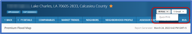
Like the Standard Flood Map Report, you will have the same ability to download the Premium Flood Map report for print or email.
Purchasing a Flood Map report
To purchase a property’s Flood Map report, click the Flood Map tab, select Add to Cart, and follow Realist’s instructions.
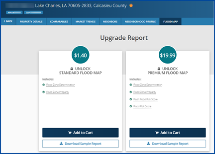
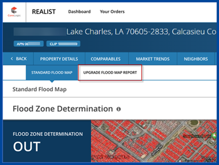
When viewing the Standard Flood Map report, click on the Upgrade Flood Map Report button at top to start upgrading.
Upgrade from Standard Flood Map to Premium Flood Map Report
You can upgrade a Standard Flood Map report to a Premium Flood Map.
Steps to Upgrade:
- Click on Upgrade Flood Map Report
- Click on Add to Cart (Note: You can add multiple premium flood map reports to cart, for different properties, prior to checkout)
- Click on the Shopping Cart icon at top-left to proceed to the checkout page
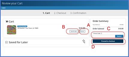
- On the Cart page, you will see the following options:
A) Remove product from shopping cart
B) Save for later
C) If applicable, add the Promo Code, and then select Redeem
D) Proceed to checkout to enter credit card information
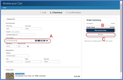
- On the Checkout page:
- A) Enter your credit card information and billing address
- B) Click Place Secure Order
- C) Edit Items to add or remove items from your cart
Access your Premium Flood Map report after purchase
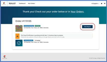
Order Confirmation Page
Once you have purchased the Premium Flood Map report(s), you’ll see an order confirmation page. If you purchased multiple flood map reports during one transaction, each Premium Map Report will appear on the same order confirmation page with its own View Report button, as indicated below.
#
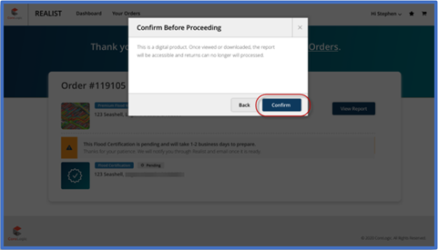
Acknowledgement of Refund Policy
Because the Premium Flood Map report is delivered as a digital product, Realist does not accept returns once you have viewed or accessed the report content. To begin viewing the Premium Flood Map report content, you must acknowledge and accept the refund policy set by clicking on the Confirm button.
View Flood Risk & Flash Flood Risk, and Print & Email reports
You can view, print, and email the Premium Flood Map Report just like other Realist reports.
When you first access this report, the top section will display the “Flood Zone Determination” (this is available as part of the Standard Flood Map Report and included in the Premium report). Scroll past the Flood Zone Determination section to the CoreLogic Flood & Flash Flood Data. You can toggle the Flood Risk Score and Flash Flood Risk Score to navigate between the two risk models. Both models offer a map with zoom in & out controls, so you can view the risk heat map at the radius you prefer.
You can print and email this report by navigating to the top right section of the report and clicking Print or Email.
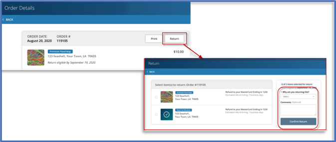
Refund
To obtain a refund for a report you haven’t accessed or viewed, click on the Your Orders button to navigate to the order summary page. Click on the Return button located to the right of the eligible report(s), select your return reason, add optional comments, and then click on the Confirm Return button. CoreLogic will issue the refund immediately; however, processing time may take 5-10 days depending on your financial institution.


